


2 Laboule - Loubaresse

Clo0413
User
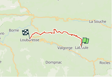

Length
16.2 km

Max alt
1458 m

Uphill gradient
986 m
Km-Effort
28 km

Min alt
660 m

Downhill gradient
430 m
Boucle
No
Creation date :
2024-09-09 06:56:49.779
Updated on :
2024-09-17 11:28:29.759
6h15
Difficulty : Very difficult

FREE GPS app for hiking
 SityTrail
IGN / Geographical institutes
SityTrail Plus
The world is yours!
About
Trail Walking of 16.2 km to be discovered at Auvergne-Rhône-Alpes, Ardèche, Laboule. This trail is proposed by Clo0413.
Positioning
Country:
France
Region :
Auvergne-Rhône-Alpes
Department/Province :
Ardèche
Municipality :
Laboule
Location:
Unknown
Start:(Dec)
Start:(UTM)
592442 ; 4937778 (31T) N.
Comments