


Saint pons Riou bourdoux 15kms 730m

Danielba
User GUIDE
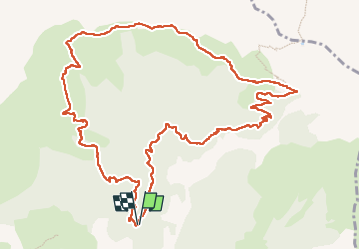

Length
14.3 km

Max alt
2347 m

Uphill gradient
750 m
Km-Effort
24 km

Min alt
1650 m

Downhill gradient
746 m
Boucle
Yes
Creation date :
2024-09-10 07:19:21.143
Updated on :
2024-09-10 17:55:09.846
6h54
Difficulty : Medium

FREE GPS app for hiking
 SityTrail
IGN / Geographical institutes
SityTrail Plus
The world is yours!
About
Trail Walking of 14.3 km to be discovered at Provence-Alpes-Côte d'Azur, Alpes-de-Haute-Provence, Saint-Pons. This trail is proposed by Danielba .
Positioning
Country:
France
Region :
Provence-Alpes-Côte d'Azur
Department/Province :
Alpes-de-Haute-Provence
Municipality :
Saint-Pons
Location:
Unknown
Start:(Dec)
Start:(UTM)
310081 ; 4921033 (32T) N.
Comments