


FORET DE SAINT GERMAIN

meillon
User
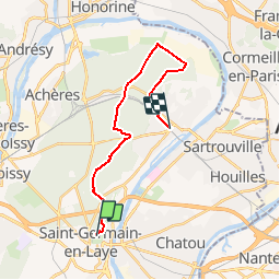

Length
17.6 km

Max alt
88 m

Uphill gradient
131 m
Km-Effort
19.5 km

Min alt
30 m

Downhill gradient
175 m
Boucle
No
Creation date :
2015-05-09 00:00:00.0
Updated on :
2015-05-09 00:00:00.0
5h00
Difficulty : Unknown

FREE GPS app for hiking
 SityTrail
IGN / Geographical institutes
SityTrail Plus
The world is yours!
About
Trail Other activity of 17.6 km to be discovered at Ile-de-France, Yvelines, Saint-Germain-en-Laye. This trail is proposed by meillon.
Description
RANDO AISEE
Positioning
Country:
France
Region :
Ile-de-France
Department/Province :
Yvelines
Municipality :
Saint-Germain-en-Laye
Location:
Saint-Germain-en-Laye
Start:(Dec)
Start:(UTM)
433893 ; 5416930 (31U) N.
Comments