


Hermeray 10km7

topophil
User
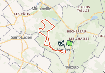

Length
10.7 km

Max alt
182 m

Uphill gradient
122 m
Km-Effort
12.3 km

Min alt
134 m

Downhill gradient
122 m
Boucle
Yes
Creation date :
2024-08-28 07:17:23.945
Updated on :
2024-09-11 10:10:22.7
2h54
Difficulty : Difficult

FREE GPS app for hiking
 SityTrail
IGN / Geographical institutes
SityTrail Plus
The world is yours!
About
Trail Walking of 10.7 km to be discovered at Ile-de-France, Yvelines, Hermeray. This trail is proposed by topophil.
Positioning
Country:
France
Region :
Ile-de-France
Department/Province :
Yvelines
Municipality :
Hermeray
Location:
Unknown
Start:(Dec)
Start:(UTM)
402386 ; 5387985 (31U) N.
Comments