


bez bedene

bouscaillou
User
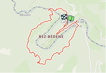

Length
3.1 km

Max alt
588 m

Uphill gradient
167 m
Km-Effort
5.3 km

Min alt
468 m

Downhill gradient
167 m
Boucle
Yes
Creation date :
2024-09-12 08:15:09.352
Updated on :
2024-09-12 10:07:16.909
1h49
Difficulty : Easy

FREE GPS app for hiking
 SityTrail
IGN / Geographical institutes
SityTrail Plus
The world is yours!
About
Trail Walking of 3.1 km to be discovered at Occitania, Aveyron, Campouriez. This trail is proposed by bouscaillou.
Positioning
Country:
France
Region :
Occitania
Department/Province :
Aveyron
Municipality :
Campouriez
Location:
Unknown
Start:(Dec)
Start:(UTM)
471863 ; 4945867 (31T) N.
Comments