


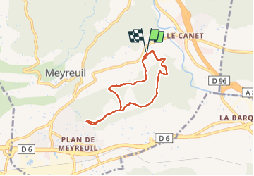
Le Deffens Valbrillant Meyreuil

ARPF1
User

Length
6.3 km

Max alt
305 m

Uphill gradient
165 m
Km-Effort
8.5 km

Min alt
185 m

Downhill gradient
164 m
Boucle
Yes
Creation date :
2024-09-12 12:03:21.223
Updated on :
2024-09-12 14:04:03.772
2h50
Difficulty : Medium

FREE GPS app for hiking
 SityTrail
IGN / Geographical institutes
SityTrail Plus
The world is yours!
About
Trail Walking of 6.3 km to be discovered at Provence-Alpes-Côte d'Azur, Bouches-du-Rhône, Meyreuil. This trail is proposed by ARPF1.
Description
7.08 kms temps de marche 2.5 h
Positioning
Country:
France
Region :
Provence-Alpes-Côte d'Azur
Department/Province :
Bouches-du-Rhône
Municipality :
Meyreuil
Location:
Unknown
Start:(Dec)
Start:(UTM)
703361 ; 4818345 (31T) N.
Comments