


GTVA Aydat Orcival

taguette
User
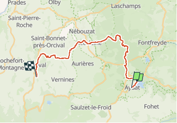

Length
26 km

Max alt
1174 m

Uphill gradient
762 m
Km-Effort
36 km

Min alt
834 m

Downhill gradient
663 m
Boucle
No
Creation date :
2024-09-12 07:18:49.764
Updated on :
2024-09-12 14:59:36.505
7h39
Difficulty : Very difficult

FREE GPS app for hiking
 SityTrail
IGN / Geographical institutes
SityTrail Plus
The world is yours!
About
Trail Walking of 26 km to be discovered at Auvergne-Rhône-Alpes, Puy-de-Dôme, Aydat. This trail is proposed by taguette.
Positioning
Country:
France
Region :
Auvergne-Rhône-Alpes
Department/Province :
Puy-de-Dôme
Municipality :
Aydat
Location:
Unknown
Start:(Dec)
Start:(UTM)
498048 ; 5056380 (31T) N.
Comments