


montabes

bouscaillou
User
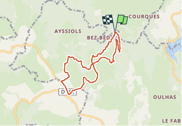

Length
8 km

Max alt
765 m

Uphill gradient
284 m
Km-Effort
11.8 km

Min alt
493 m

Downhill gradient
282 m
Boucle
Yes
Creation date :
2024-09-12 12:18:40.063
Updated on :
2024-09-12 15:02:44.947
2h43
Difficulty : Medium

FREE GPS app for hiking
 SityTrail
IGN / Geographical institutes
SityTrail Plus
The world is yours!
About
Trail Walking of 8 km to be discovered at Occitania, Aveyron, Florentin-la-Capelle. This trail is proposed by bouscaillou.
Positioning
Country:
France
Region :
Occitania
Department/Province :
Aveyron
Municipality :
Florentin-la-Capelle
Location:
Unknown
Start:(Dec)
Start:(UTM)
471993 ; 4945913 (31T) N.
Comments