


TET

olivieraron
User
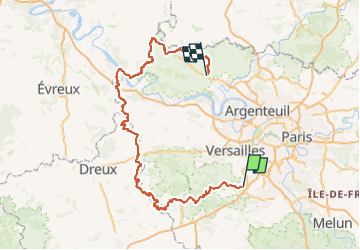

Length
224 km

Max alt
183 m

Uphill gradient
2328 m
Km-Effort
255 km

Min alt
10 m

Downhill gradient
2372 m
Boucle
No
Creation date :
2024-09-13 10:09:31.021
Updated on :
2024-09-13 10:44:18.416
8h20
Difficulty : Very easy

FREE GPS app for hiking
 SityTrail
IGN / Geographical institutes
SityTrail Plus
The world is yours!
About
Trail Moto cross of 224 km to be discovered at Ile-de-France, Essonne, Saint-Jean-de-Beauregard. This trail is proposed by olivieraron.
Points of interest


Positioning
Country:
France
Region :
Ile-de-France
Department/Province :
Essonne
Municipality :
Saint-Jean-de-Beauregard
Location:
Unknown
Start:(Dec)
Start:(UTM)
438719 ; 5391582 (31U) N.
Comments