


cauterers Lac de Gaube Rs

LouisROGER
User GUIDE
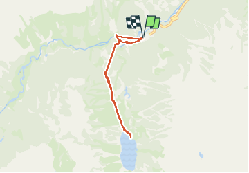

Length
6.1 km

Max alt
1780 m

Uphill gradient
368 m
Km-Effort
11 km

Min alt
1464 m

Downhill gradient
366 m
Boucle
Yes
Creation date :
2024-09-10 08:46:58.771
Updated on :
2024-09-13 12:51:35.127
4h58
Difficulty : Medium

FREE GPS app for hiking
 SityTrail
IGN / Geographical institutes
SityTrail Plus
The world is yours!
About
Trail Walking of 6.1 km to be discovered at Occitania, Hautespyrenees, Cauterets. This trail is proposed by LouisROGER.
Positioning
Country:
France
Region :
Occitania
Department/Province :
Hautespyrenees
Municipality :
Cauterets
Location:
Unknown
Start:(Dec)
Start:(UTM)
734015 ; 4748378 (30T) N.
Comments