


Narreyroux

Vinceneux
User
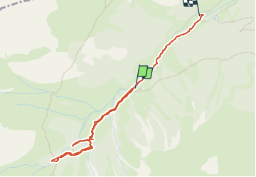

Length
4.2 km

Max alt
2145 m

Uphill gradient
277 m
Km-Effort
8.2 km

Min alt
1788 m

Downhill gradient
366 m
Boucle
No
Creation date :
2024-08-12 08:50:29.874
Updated on :
2024-09-13 13:29:51.606
2h42
Difficulty : Medium

FREE GPS app for hiking
 SityTrail
IGN / Geographical institutes
SityTrail Plus
The world is yours!
About
Trail Walking of 4.2 km to be discovered at Provence-Alpes-Côte d'Azur, Hautes-Alpes, Puy-Saint-Vincent. This trail is proposed by Vinceneux.
Positioning
Country:
France
Region :
Provence-Alpes-Côte d'Azur
Department/Province :
Hautes-Alpes
Municipality :
Puy-Saint-Vincent
Location:
Unknown
Start:(Dec)
Start:(UTM)
298607 ; 4965451 (32T) N.
Comments