


2024-09-13_17h58m06_la-traversee-est-ouest-du-vercors-par-le-gr93-etape-2 (1)

zochnia
User
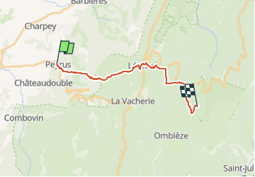

Length
17.3 km

Max alt
1344 m

Uphill gradient
1305 m
Km-Effort
32 km

Min alt
394 m

Downhill gradient
471 m
Boucle
No
Creation date :
2024-09-13 15:58:06.587
Updated on :
2024-09-13 15:58:08.993

FREE GPS app for hiking
 SityTrail
IGN / Geographical institutes
SityTrail Plus
The world is yours!
About
Trail of 17.3 km to be discovered at Auvergne-Rhône-Alpes, Drôme, Peyrus. This trail is proposed by zochnia.
Positioning
Country:
France
Region :
Auvergne-Rhône-Alpes
Department/Province :
Drôme
Municipality :
Peyrus
Location:
Unknown
Start:(Dec)
Start:(UTM)
666476 ; 4975400 (31T) N.
Comments