


Beausoleil

sameja
User
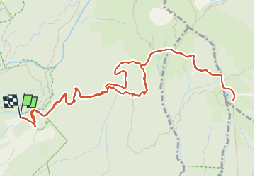

Length
10 km

Max alt
1206 m

Uphill gradient
545 m
Km-Effort
17.3 km

Min alt
746 m

Downhill gradient
542 m
Boucle
Yes
Creation date :
2024-09-14 10:17:58.0
Updated on :
2024-09-14 12:21:08.528
1h45
Difficulty : Medium

FREE GPS app for hiking
 SityTrail
IGN / Geographical institutes
SityTrail Plus
The world is yours!
About
Trail Trail of 10 km to be discovered at Guadeloupe, Unknown, Saint-Claude. This trail is proposed by sameja.
Description
La citerne
Photos


Positioning
Country:
France
Region :
Guadeloupe
Department/Province :
Unknown
Municipality :
Saint-Claude
Location:
Unknown
Start:(Dec)
Start:(UTM)
641123 ; 1772843 (20Q) N.
Comments