


Pic de Belh par la crête des Isards

lebarça
User
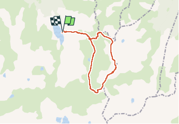

Length
14.4 km

Max alt
2370 m

Uphill gradient
950 m
Km-Effort
27 km

Min alt
1545 m

Downhill gradient
949 m
Boucle
Yes
Creation date :
2024-09-14 06:55:35.0
Updated on :
2024-09-14 18:49:04.375

FREE GPS app for hiking
 SityTrail
IGN / Geographical institutes
SityTrail Plus
The world is yours!
About
Trail of 14.4 km to be discovered at Occitania, Ariège, Aston. This trail is proposed by lebarça.
Positioning
Country:
France
Region :
Occitania
Department/Province :
Ariège
Municipality :
Aston
Location:
Unknown
Start:(Dec)
Start:(UTM)
394188 ; 4725294 (31T) N.
Comments