


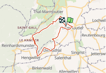
Circuit du Tannenwald

VacheKiri67
User

Length
15.4 km

Max alt
368 m

Uphill gradient
339 m
Km-Effort
19.9 km

Min alt
218 m

Downhill gradient
339 m
Boucle
Yes
Creation date :
2015-05-10 00:00:00.0
Updated on :
2015-05-10 00:00:00.0
4h14
Difficulty : Medium

FREE GPS app for hiking
 SityTrail
IGN / Geographical institutes
SityTrail Plus
The world is yours!
About
Trail Walking of 15.4 km to be discovered at Grand Est, Bas-Rhin, Marmoutier. This trail is proposed by VacheKiri67.
Description
Faite le 10/05/2015 avec notre fils de 10 ans. Circuit du Tannenwald : balisage anneau bleu. Départ rue de la gare à Marmoutier. La durée indiquée pour le circuit est de 4h00 pour 13km.
Photos


Positioning
Country:
France
Region :
Grand Est
Department/Province :
Bas-Rhin
Municipality :
Marmoutier
Location:
Unknown
Start:(Dec)
Start:(UTM)
380339 ; 5394405 (32U) N.
Comments
Un parcours qui ne paie pas de mine ! Et pourtant la variété est au rendez-vous : prairies, vergers, forêts, belles vues... Ne pas oublier d'aller visiter l'abbatiale au centre de Marmoutier.