


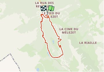
Le lac Miroir

Nuance
User

Length
7.3 km

Max alt
2230 m

Uphill gradient
543 m
Km-Effort
14.6 km

Min alt
1680 m

Downhill gradient
549 m
Boucle
Yes
Creation date :
2024-09-15 08:43:05.0
Updated on :
2024-09-15 13:40:22.53
4h12
Difficulty : Difficult

FREE GPS app for hiking
 SityTrail
IGN / Geographical institutes
SityTrail Plus
The world is yours!
About
Trail Walking of 7.3 km to be discovered at Provence-Alpes-Côte d'Azur, Hautes-Alpes, Ceillac. This trail is proposed by Nuance.
Positioning
Country:
France
Region :
Provence-Alpes-Côte d'Azur
Department/Province :
Hautes-Alpes
Municipality :
Ceillac
Location:
Unknown
Start:(Dec)
Start:(UTM)
324820 ; 4946533 (32T) N.
Comments