


Viltain 2024 final

olivieraron
User
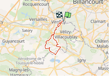

Length
19.5 km

Max alt
187 m

Uphill gradient
360 m
Km-Effort
24 km

Min alt
87 m

Downhill gradient
360 m
Boucle
Yes
Creation date :
2024-09-15 16:33:38.685
Updated on :
2024-09-15 16:34:12.794
5h31
Difficulty : Very difficult

FREE GPS app for hiking
 SityTrail
IGN / Geographical institutes
SityTrail Plus
The world is yours!
About
Trail Walking of 19.5 km to be discovered at Ile-de-France, Yvelines, Viroflay. This trail is proposed by olivieraron.
Positioning
Country:
France
Region :
Ile-de-France
Department/Province :
Yvelines
Municipality :
Viroflay
Location:
Unknown
Start:(Dec)
Start:(UTM)
440113 ; 5405524 (31U) N.
Comments