


Argentiere

michauxpaul
User
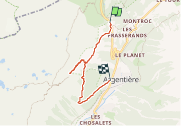

Length
5.9 km

Max alt
1908 m

Uphill gradient
467 m
Km-Effort
12.7 km

Min alt
1251 m

Downhill gradient
627 m
Boucle
No
Creation date :
2024-09-15 13:56:58.0
Updated on :
2024-09-15 18:37:22.27
4h23
Difficulty : Difficult

FREE GPS app for hiking
 SityTrail
IGN / Geographical institutes
SityTrail Plus
The world is yours!
About
Trail Walking of 5.9 km to be discovered at Auvergne-Rhône-Alpes, Upper Savoy, Chamonix-Mont-Blanc. This trail is proposed by michauxpaul.
Description
Trek
Photos


Positioning
Country:
France
Region :
Auvergne-Rhône-Alpes
Department/Province :
Upper Savoy
Municipality :
Chamonix-Mont-Blanc
Location:
Unknown
Start:(Dec)
Start:(UTM)
339399 ; 5095842 (32T) N.
Comments