


Le Ménil en circuit partiel

Emelle
User
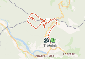

Length
11.2 km

Max alt
1581 m

Uphill gradient
690 m
Km-Effort
20 km

Min alt
926 m

Downhill gradient
689 m
Boucle
Yes
Creation date :
2024-09-16 09:58:38.638
Updated on :
2024-09-16 09:59:40.01
4h37
Difficulty : Medium

FREE GPS app for hiking
 SityTrail
IGN / Geographical institutes
SityTrail Plus
The world is yours!
About
Trail Walking of 11.2 km to be discovered at Auvergne-Rhône-Alpes, Isère, Tréminis. This trail is proposed by Emelle.
Positioning
Country:
France
Region :
Auvergne-Rhône-Alpes
Department/Province :
Isère
Municipality :
Tréminis
Location:
Unknown
Start:(Dec)
Start:(UTM)
719077 ; 4958512 (31T) N.
Comments