


Citadelle de BURON

Benteux
User
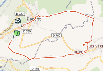

Length
5.5 km

Max alt
656 m

Uphill gradient
213 m
Km-Effort
8.4 km

Min alt
445 m

Downhill gradient
222 m
Boucle
No
Creation date :
2024-09-16 07:08:12.069
Updated on :
2024-09-16 10:11:59.255
2h40
Difficulty : Easy

FREE GPS app for hiking
 SityTrail
IGN / Geographical institutes
SityTrail Plus
The world is yours!
About
Trail Walking of 5.5 km to be discovered at Auvergne-Rhône-Alpes, Puy-de-Dôme, Parent. This trail is proposed by Benteux.
Description
marche
Positioning
Country:
France
Region :
Auvergne-Rhône-Alpes
Department/Province :
Puy-de-Dôme
Municipality :
Parent
Location:
Unknown
Start:(Dec)
Start:(UTM)
517405 ; 5051758 (31T) N.
Comments