


Montpeyroux

Benteux
User
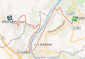

Length
4.7 km

Max alt
483 m

Uphill gradient
150 m
Km-Effort
6.6 km

Min alt
346 m

Downhill gradient
118 m
Boucle
No
Creation date :
2024-09-16 12:00:35.126
Updated on :
2024-09-16 14:22:07.432
1h58
Difficulty : Easy

FREE GPS app for hiking
 SityTrail
IGN / Geographical institutes
SityTrail Plus
The world is yours!
About
Trail Walking of 4.7 km to be discovered at Auvergne-Rhône-Alpes, Puy-de-Dôme, Parent. This trail is proposed by Benteux.
Description
marche
Positioning
Country:
France
Region :
Auvergne-Rhône-Alpes
Department/Province :
Puy-de-Dôme
Municipality :
Parent
Location:
Unknown
Start:(Dec)
Start:(UTM)
517604 ; 5052066 (31T) N.
Comments