


forêt de la Loubatière

Mascart
User

Length
9.3 km

Max alt
806 m

Uphill gradient
192 m
Km-Effort
11.9 km

Min alt
717 m

Downhill gradient
198 m
Boucle
Yes
Creation date :
2024-09-17 11:34:09.648
Updated on :
2024-09-17 15:48:30.4
2h34
Difficulty : Medium

FREE GPS app for hiking
 SityTrail
IGN / Geographical institutes
SityTrail Plus
The world is yours!
About
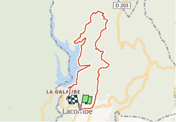
Trail Walking of 9.3 km to be discovered at Occitania, Aude, Lacombe. This trail is proposed by Mascart.
Description
départ de Lacombe en boucle et retour en longeant le lac de la Galaube.
Positioning
Country:
France
Region :
Occitania
Department/Province :
Aude
Municipality :
Lacombe
Location:
Unknown
Start:(Dec)
Start:(UTM)
437900 ; 4805210 (31T) N.
Comments