


via Columbani 12 du 29.08.2024

bene_dictus77
User

Length
22 km

Max alt
151 m

Uphill gradient
200 m
Km-Effort
24 km

Min alt
93 m

Downhill gradient
195 m
Boucle
No
Creation date :
2024-08-29 08:27:05.493
Updated on :
2024-09-18 05:12:12.037
6h45
Difficulty : Easy

FREE GPS app for hiking
 SityTrail
IGN / Geographical institutes
SityTrail Plus
The world is yours!
About
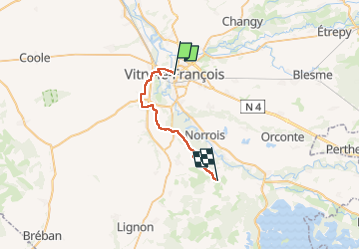
Trail Walking of 22 km to be discovered at Grand Est, Marne, Vitry-le-François. This trail is proposed by bene_dictus77.
Description
de Vitry LF à St Rémy en Bouzemont
Positioning
Country:
France
Region :
Grand Est
Department/Province :
Marne
Municipality :
Vitry-le-François
Location:
Unknown
Start:(Dec)
Start:(UTM)
616596 ; 5398172 (31U) N.
Comments