


Via Columbani 13 du 30.08.2024

bene_dictus77
User
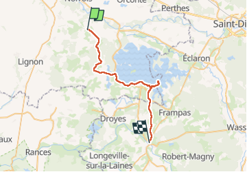

Length
32 km

Max alt
160 m

Uphill gradient
251 m
Km-Effort
35 km

Min alt
106 m

Downhill gradient
231 m
Boucle
No
Creation date :
2024-08-30 06:10:51.262
Updated on :
2024-09-18 05:12:14.369
9h37
Difficulty : Medium

FREE GPS app for hiking
 SityTrail
IGN / Geographical institutes
SityTrail Plus
The world is yours!
About
Trail Walking of 32 km to be discovered at Grand Est, Marne, Saint-Remy-en-Bouzemont-Saint-Genest-et-Isson. This trail is proposed by bene_dictus77.
Description
de Saint Rémy à Montier en Der
Positioning
Country:
France
Region :
Grand Est
Department/Province :
Marne
Municipality :
Saint-Remy-en-Bouzemont-Saint-Genest-et-Isson
Location:
Unknown
Start:(Dec)
Start:(UTM)
621301 ; 5387564 (31U) N.
Comments