


AF-2-2024 du 15.09.2024

bene_dictus77
User

Length
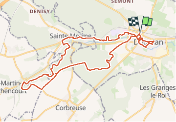
23 km

Max alt
168 m

Uphill gradient
264 m
Km-Effort
27 km

Min alt
92 m

Downhill gradient
264 m
Boucle
Yes
Creation date :
2024-09-15 07:51:08.523
Updated on :
2024-09-18 05:12:19.186
7h16
Difficulty : Easy

FREE GPS app for hiking
 SityTrail
IGN / Geographical institutes
SityTrail Plus
The world is yours!
About
Trail Walking of 23 km to be discovered at Ile-de-France, Essonne, Dourdan. This trail is proposed by bene_dictus77.
Description
Autour de Dourdan
Positioning
Country:
France
Region :
Ile-de-France
Department/Province :
Essonne
Municipality :
Dourdan
Location:
Unknown
Start:(Dec)
Start:(UTM)
426900 ; 5376057 (31U) N.
Comments