


Ayeneux

castorgris
User
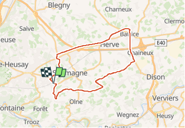

Length
27 km

Max alt
331 m

Uphill gradient
328 m
Km-Effort
32 km

Min alt
168 m

Downhill gradient
327 m
Boucle
Yes
Creation date :
2024-09-19 07:32:51.0
Updated on :
2024-09-19 09:53:09.298

FREE GPS app for hiking
 SityTrail
IGN / Geographical institutes
SityTrail Plus
The world is yours!
About
Trail of 27 km to be discovered at Wallonia, Liège, Olne. This trail is proposed by castorgris.
Positioning
Country:
Belgium
Region :
Wallonia
Department/Province :
Liège
Municipality :
Olne
Location:
Unknown
Start:(Dec)
Start:(UTM)
692348 ; 5609470 (31U) N.
Comments