


Tour du Ménil

Luc Saint-guillain
User
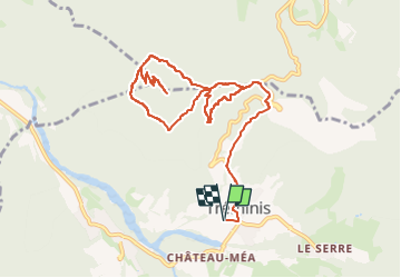

Length
11.8 km

Max alt
1581 m

Uphill gradient
710 m
Km-Effort
21 km

Min alt
906 m

Downhill gradient
710 m
Boucle
Yes
Creation date :
2024-09-19 07:44:35.921
Updated on :
2024-12-05 08:22:33.669
4h49
Difficulty : Easy

FREE GPS app for hiking
 SityTrail
IGN / Geographical institutes
SityTrail Plus
The world is yours!
About
Trail Walking of 11.8 km to be discovered at Auvergne-Rhône-Alpes, Isère, Tréminis. This trail is proposed by Luc Saint-guillain.
Description
Départ du cimetière de Tréminis - L'Eglise.
Positioning
Country:
France
Region :
Auvergne-Rhône-Alpes
Department/Province :
Isère
Municipality :
Tréminis
Location:
Unknown
Start:(Dec)
Start:(UTM)
718959 ; 4958365 (31T) N.
Comments