


evenos

bernir
User
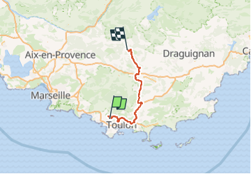

Length
105 km

Max alt
424 m

Uphill gradient
1878 m
Km-Effort
129 km

Min alt
13 m

Downhill gradient
1772 m
Boucle
No
Creation date :
2024-09-19 09:18:05.843
Updated on :
2024-09-19 18:09:02.685
8h50
Difficulty : Medium

FREE GPS app for hiking
 SityTrail
IGN / Geographical institutes
SityTrail Plus
The world is yours!
About
Trail Walking of 105 km to be discovered at Provence-Alpes-Côte d'Azur, Var, Évenos. This trail is proposed by bernir.
Positioning
Country:
France
Region :
Provence-Alpes-Côte d'Azur
Department/Province :
Var
Municipality :
Évenos
Location:
Unknown
Start:(Dec)
Start:(UTM)
730798 ; 4782869 (31T) N.
Comments