


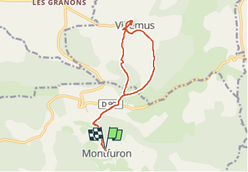
Montfuron Villemus

mhetpierre
User

Length
7.6 km

Max alt
676 m

Uphill gradient
171 m
Km-Effort
9.8 km

Min alt
571 m

Downhill gradient
171 m
Boucle
Yes
Creation date :
2024-09-20 08:00:31.0
Updated on :
2024-09-27 15:39:24.84
2h14
Difficulty : Medium

FREE GPS app for hiking
 SityTrail
IGN / Geographical institutes
SityTrail Plus
The world is yours!
About
Trail Walking of 7.6 km to be discovered at Provence-Alpes-Côte d'Azur, Alpes-de-Haute-Provence, Montfuron. This trail is proposed by mhetpierre.
Positioning
Country:
France
Region :
Provence-Alpes-Côte d'Azur
Department/Province :
Alpes-de-Haute-Provence
Municipality :
Montfuron
Location:
Unknown
Start:(Dec)
Start:(UTM)
716609 ; 4857207 (31T) N.
Comments