


col De la ruchère 240920

ppn
User
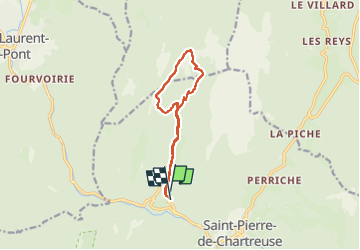

Length
10.7 km

Max alt
1433 m

Uphill gradient
585 m
Km-Effort
18.5 km

Min alt
859 m

Downhill gradient
585 m
Boucle
Yes
Creation date :
2024-09-20 09:17:19.04
Updated on :
2024-09-20 14:03:30.25
4h05
Difficulty : Medium

FREE GPS app for hiking
 SityTrail
IGN / Geographical institutes
SityTrail Plus
The world is yours!
About
Trail Walking of 10.7 km to be discovered at Auvergne-Rhône-Alpes, Isère, Saint-Pierre-de-Chartreuse. This trail is proposed by ppn.
Positioning
Country:
France
Region :
Auvergne-Rhône-Alpes
Department/Province :
Isère
Municipality :
Saint-Pierre-de-Chartreuse
Location:
Unknown
Start:(Dec)
Start:(UTM)
718575 ; 5025726 (31T) N.
Comments