


pic Touleau

verozerr
User
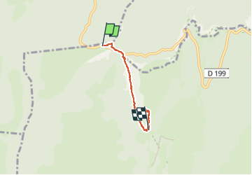

Length
3.9 km

Max alt
1530 m

Uphill gradient
261 m
Km-Effort
7.2 km

Min alt
1297 m

Downhill gradient
204 m
Boucle
No
Creation date :
2024-09-20 13:02:09.059
Updated on :
2024-09-20 14:54:35.537
1h51
Difficulty : Medium

FREE GPS app for hiking
 SityTrail
IGN / Geographical institutes
SityTrail Plus
The world is yours!
About
Trail Walking of 3.9 km to be discovered at Auvergne-Rhône-Alpes, Drôme, Omblèze. This trail is proposed by verozerr.
Description
pic Touleau
Positioning
Country:
France
Region :
Auvergne-Rhône-Alpes
Department/Province :
Drôme
Municipality :
Omblèze
Location:
Unknown
Start:(Dec)
Start:(UTM)
675963 ; 4974184 (31T) N.
Comments