


Circuit des lacs, 04-09-2024

Christiancordin
User
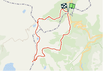

Length
9.1 km

Max alt
2676 m

Uphill gradient
459 m
Km-Effort
15.2 km

Min alt
2265 m

Downhill gradient
453 m
Boucle
Yes
Creation date :
2024-09-20 16:32:58.629
Updated on :
2024-09-20 16:58:22.785
3h27
Difficulty : Medium

FREE GPS app for hiking
 SityTrail
IGN / Geographical institutes
SityTrail Plus
The world is yours!
About
Trail On foot of 9.1 km to be discovered at Provence-Alpes-Côte d'Azur, Alpes-de-Haute-Provence, Uvernet-Fours. This trail is proposed by Christiancordin.
Description
D Pk du col de la Cayolle, GR 56B, col de la petite Cayolle, lac de la petite Cayolle, lac des Garrets, vue sur le lac d'Allos, pas du Lausson, GR52, col de la Cayolle.
Photos


Positioning
Country:
France
Region :
Provence-Alpes-Côte d'Azur
Department/Province :
Alpes-de-Haute-Provence
Municipality :
Uvernet-Fours
Location:
Unknown
Start:(Dec)
Start:(UTM)
319917 ; 4903207 (32T) N.
Comments