


nyons_venterol_les_cornuds_nyons-19660765-1726862304-435

Laurent Grospelly
User
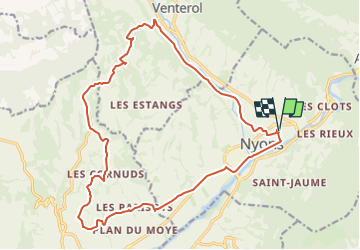

Length
21 km

Max alt
467 m

Uphill gradient
346 m
Km-Effort
25 km

Min alt
241 m

Downhill gradient
346 m
Boucle
Yes
Creation date :
2024-09-21 05:47:45.474
Updated on :
2024-09-21 05:47:45.474

FREE GPS app for hiking
 SityTrail
IGN / Geographical institutes
SityTrail Plus
The world is yours!
About
Trail of 21 km to be discovered at Auvergne-Rhône-Alpes, Drôme, Nyons. This trail is proposed by Laurent Grospelly.
Positioning
Country:
France
Region :
Auvergne-Rhône-Alpes
Department/Province :
Drôme
Municipality :
Nyons
Location:
Unknown
Start:(Dec)
Start:(UTM)
670105 ; 4913942 (31T) N.
Comments