


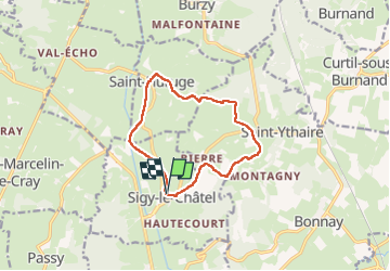
Sigy-le-Châtel

Bonnefois Bernard
User

Length
10.9 km

Max alt
410 m

Uphill gradient
255 m
Km-Effort
14.3 km

Min alt
217 m

Downhill gradient
259 m
Boucle
Yes
Creation date :
2024-09-22 13:02:16.892
Updated on :
2024-09-22 13:04:36.632
3h15
Difficulty : Medium

FREE GPS app for hiking
 SityTrail
IGN / Geographical institutes
SityTrail Plus
The world is yours!
About
Trail Walking of 10.9 km to be discovered at Bourgogne-Franche-Comté, Saône-et-Loire, Sigy-le-Châtel. This trail is proposed by Bonnefois Bernard.
Positioning
Country:
France
Region :
Bourgogne-Franche-Comté
Department/Province :
Saône-et-Loire
Municipality :
Sigy-le-Châtel
Location:
Unknown
Start:(Dec)
Start:(UTM)
620583 ; 5156967 (31T) N.
Comments