


Le Trianon A/R

Lamartiniere
User GUIDE
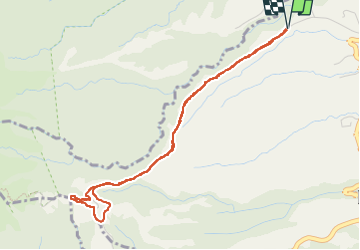

Length
6.6 km

Max alt
762 m

Uphill gradient
346 m
Km-Effort
11.2 km

Min alt
419 m

Downhill gradient
347 m
Boucle
Yes
Creation date :
2024-09-22 10:56:57.758
Updated on :
2024-09-22 13:53:31.792
2h30
Difficulty : Medium

FREE GPS app for hiking
 SityTrail
IGN / Geographical institutes
SityTrail Plus
The world is yours!
About
Trail Walking of 6.6 km to be discovered at Martinique, Unknown, L'Ajoupa-Bouillon. This trail is proposed by Lamartiniere.
Positioning
Country:
France
Region :
Martinique
Department/Province :
Unknown
Municipality :
L'Ajoupa-Bouillon
Location:
Unknown
Start:(Dec)
Start:(UTM)
701262 ; 1639267 (20P) N.
Comments