


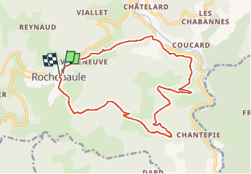
Rochepaule

jpblimond
User

Length
9.9 km

Max alt
921 m

Uphill gradient
421 m
Km-Effort
15.5 km

Min alt
628 m

Downhill gradient
414 m
Boucle
Yes
Creation date :
2024-09-22 13:23:52.0
Updated on :
2024-09-22 18:26:46.059
3h30
Difficulty : Difficult

FREE GPS app for hiking
 SityTrail
IGN / Geographical institutes
SityTrail Plus
The world is yours!
About
Trail Walking of 9.9 km to be discovered at Auvergne-Rhône-Alpes, Ardèche, Rochepaule. This trail is proposed by jpblimond.
Positioning
Country:
France
Region :
Auvergne-Rhône-Alpes
Department/Province :
Ardèche
Municipality :
Rochepaule
Location:
Unknown
Start:(Dec)
Start:(UTM)
614655 ; 4992616 (31T) N.
Comments