


auvers 2024

olivieraron
User
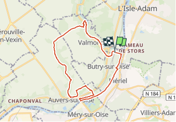

Length
15.6 km

Max alt
101 m

Uphill gradient
173 m
Km-Effort
17.9 km

Min alt
19 m

Downhill gradient
173 m
Boucle
Yes
Creation date :
2024-09-24 06:30:25.161
Updated on :
2024-09-24 06:31:40.293
4h04
Difficulty : Difficult

FREE GPS app for hiking
 SityTrail
IGN / Geographical institutes
SityTrail Plus
The world is yours!
About
Trail Walking of 15.6 km to be discovered at Ile-de-France, Val-d'Oise, Butry-sur-Oise. This trail is proposed by olivieraron.
Positioning
Country:
France
Region :
Ile-de-France
Department/Province :
Val-d'Oise
Municipality :
Butry-sur-Oise
Location:
Unknown
Start:(Dec)
Start:(UTM)
441780 ; 5437986 (31U) N.
Comments