Barnas (Botanic-Champhagot-Antenne-Passerelle)

Rudy07
User
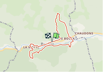

Length
8 km

Max alt
590 m

Uphill gradient
295 m
Km-Effort
11.9 km

Min alt
438 m

Downhill gradient
298 m
Boucle
Yes
Creation date :
2024-09-24 06:04:06.935
Updated on :
2024-11-14 09:39:26.743
2h42
Difficulty : Medium

FREE GPS app for hiking
 SityTrail
IGN / Geographical institutes
SityTrail Plus
The world is yours!
About
Trail Walking of 8 km to be discovered at Auvergne-Rhône-Alpes, Ardèche, Barnas. This trail is proposed by Rudy07.
Positioning
Country:
France
Region :
Auvergne-Rhône-Alpes
Department/Province :
Ardèche
Municipality :
Barnas
Location:
Unknown
Start:(Dec)
Start:(UTM)
592628 ; 4946774 (31T) N.
Comments