


lac du roumagaou

derrives
User

Length
49 km

Max alt
913 m

Uphill gradient
994 m
Km-Effort
62 km

Min alt
203 m

Downhill gradient
990 m
Boucle
Yes
Creation date :
2015-12-12 00:00:00.0
Updated on :
2015-12-12 00:00:00.0
4h02
Difficulty : Difficult

FREE GPS app for hiking
 SityTrail
IGN / Geographical institutes
SityTrail Plus
The world is yours!
About
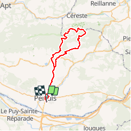
Trail Mountain bike of 49 km to be discovered at Provence-Alpes-Côte d'Azur, Vaucluse, Pertuis. This trail is proposed by derrives.
Description
Pertuis la Bastide du bois
le luberon
lac de Roumagaou
Pertuis
Positioning
Country:
France
Region :
Provence-Alpes-Côte d'Azur
Department/Province :
Vaucluse
Municipality :
Pertuis
Location:
Unknown
Start:(Dec)
Start:(UTM)
702042 ; 4840263 (31T) N.
Comments