


la gaillarde 25-09-24

cb8310
User
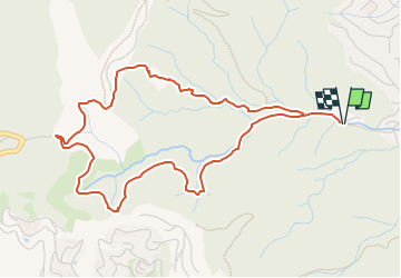

Length
5.5 km

Max alt
169 m

Uphill gradient
177 m
Km-Effort
7.9 km

Min alt
16 m

Downhill gradient
178 m
Boucle
Yes
Creation date :
2024-09-25 12:38:12.497
Updated on :
2024-11-14 07:20:59.648
1h47
Difficulty : Medium

FREE GPS app for hiking
 SityTrail
IGN / Geographical institutes
SityTrail Plus
The world is yours!
About
Trail Walking of 5.5 km to be discovered at Provence-Alpes-Côte d'Azur, Var, Roquebrune-sur-Argens. This trail is proposed by cb8310.
Positioning
Country:
France
Region :
Provence-Alpes-Côte d'Azur
Department/Province :
Var
Municipality :
Roquebrune-sur-Argens
Location:
Unknown
Start:(Dec)
Start:(UTM)
313797 ; 4804285 (32T) N.
Comments