


merurey

mcterret
User
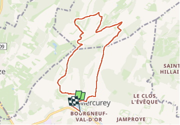

Length
9 km

Max alt
333 m

Uphill gradient
206 m
Km-Effort
11.8 km

Min alt
238 m

Downhill gradient
209 m
Boucle
No
Creation date :
2024-09-25 12:41:44.367
Updated on :
2024-09-25 15:21:24.848
2h38
Difficulty : Easy

FREE GPS app for hiking
 SityTrail
IGN / Geographical institutes
SityTrail Plus
The world is yours!
About
Trail Walking of 9 km to be discovered at Bourgogne-Franche-Comté, Saône-et-Loire, Mercurey. This trail is proposed by mcterret.
Description
randonnée dans les vignes
Positioning
Country:
France
Region :
Bourgogne-Franche-Comté
Department/Province :
Saône-et-Loire
Municipality :
Mercurey
Location:
Unknown
Start:(Dec)
Start:(UTM)
630514 ; 5188654 (31T) N.
Comments