


gap_vizille-oct2023

aeldin
User
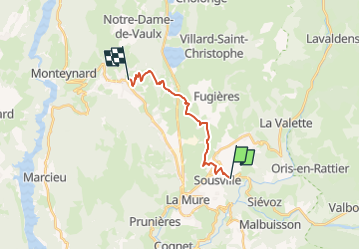

Length
13.4 km

Max alt
1245 m

Uphill gradient
542 m
Km-Effort
20 km

Min alt
806 m

Downhill gradient
415 m
Boucle
No
Creation date :
2024-09-25 20:54:29.577
Updated on :
2024-09-25 20:57:04.963
2h39
Difficulty : Medium

FREE GPS app for hiking
 SityTrail
IGN / Geographical institutes
SityTrail Plus
The world is yours!
About
Trail Horseback riding of 13.4 km to be discovered at Auvergne-Rhône-Alpes, Isère, Nantes-en-Rattier. This trail is proposed by aeldin.

Positioning
Country:
France
Region :
Auvergne-Rhône-Alpes
Department/Province :
Isère
Municipality :
Nantes-en-Rattier
Location:
Unknown
Start:(Dec)
Start:(UTM)
722274 ; 4977300 (31T) N.
Comments