


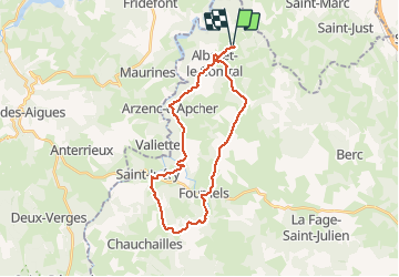
ALBARET 28 km VTT St Juéry

benoit48
User

Length
28 km

Max alt
1125 m

Uphill gradient
637 m
Km-Effort
37 km

Min alt
927 m

Downhill gradient
635 m
Boucle
Yes
Creation date :
2018-01-06 00:00:00.0
Updated on :
2018-01-06 00:00:00.0
2h00
Difficulty : Easy

FREE GPS app for hiking
 SityTrail
IGN / Geographical institutes
SityTrail Plus
The world is yours!
About
Trail Mountain bike of 28 km to be discovered at Occitania, Lozère, Albaret-le-Comtal. This trail is proposed by benoit48.
Description
Albaret > Mortesagne > Volpière > Fournels > Fauge > Genestuéjols > St Juéry > Le Mazel > Courbepeyre > Arzenc d'apacher > Le Villaret > Albaret
Positioning
Country:
France
Region :
Occitania
Department/Province :
Lozère
Municipality :
Albaret-le-Comtal
Location:
Unknown
Start:(Dec)
Start:(UTM)
510911 ; 4969998 (31T) N.
Comments