


Ste anne la Palud

cron
User
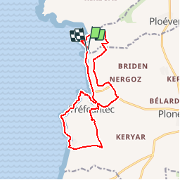

Length
14.7 km

Max alt
64 m

Uphill gradient
205 m
Km-Effort
17.4 km

Min alt
1 m

Downhill gradient
208 m
Boucle
Yes
Creation date :
2015-05-14 00:00:00.0
Updated on :
2015-05-14 00:00:00.0
4h35
Difficulty : Easy

FREE GPS app for hiking
 SityTrail
IGN / Geographical institutes
SityTrail Plus
The world is yours!
About
Trail Walking of 14.7 km to be discovered at Brittany, Finistère, Ploéven. This trail is proposed by cron.
Positioning
Country:
France
Region :
Brittany
Department/Province :
Finistère
Municipality :
Ploéven
Location:
Unknown
Start:(Dec)
Start:(UTM)
405405 ; 5333490 (30U) N.
Comments