


Montmort-Lucy du 30-09-2024 Les Virades

VANDERPUTTENMi
User GUIDE
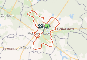

Length
19 km

Max alt
237 m

Uphill gradient
296 m
Km-Effort
23 km

Min alt
162 m

Downhill gradient
296 m
Boucle
Yes
Creation date :
2024-09-29 06:29:20.704
Updated on :
2024-09-29 19:18:56.699
5h12
Difficulty : Very difficult

FREE GPS app for hiking
 SityTrail
IGN / Geographical institutes
SityTrail Plus
The world is yours!
About
Trail Walking of 19 km to be discovered at Grand Est, Marne, Montmort-Lucy. This trail is proposed by VANDERPUTTENMi.
Photos


Positioning
Country:
France
Region :
Grand Est
Department/Province :
Marne
Municipality :
Montmort-Lucy
Location:
Unknown
Start:(Dec)
Start:(UTM)
559817 ; 5419655 (31U) N.
Comments