


Clermont Marcounat fait 2024

pidjam
User
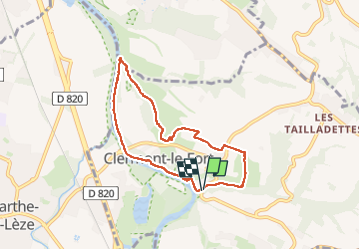

Length
7.3 km

Max alt
246 m

Uphill gradient
176 m
Km-Effort
9.7 km

Min alt
155 m

Downhill gradient
177 m
Boucle
Yes
Creation date :
2024-09-29 11:59:49.362
Updated on :
2024-09-29 15:28:45.836
1h58
Difficulty : Easy

FREE GPS app for hiking
 SityTrail
IGN / Geographical institutes
SityTrail Plus
The world is yours!
About
Trail Walking of 7.3 km to be discovered at Occitania, Haute-Garonne, Clermont-le-Fort. This trail is proposed by pidjam.
Positioning
Country:
France
Region :
Occitania
Department/Province :
Haute-Garonne
Municipality :
Clermont-le-Fort
Location:
Unknown
Start:(Dec)
Start:(UTM)
373343 ; 4812618 (31T) N.
Comments