


Tt

olivieraron
User
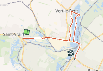

Length
6.5 km

Max alt
70 m

Uphill gradient
48 m
Km-Effort
7.1 km

Min alt
46 m

Downhill gradient
45 m
Boucle
No
Creation date :
2024-09-29 11:53:32.0
Updated on :
2024-09-29 15:30:59.685
1h24
Difficulty : Medium

FREE GPS app for hiking
 SityTrail
IGN / Geographical institutes
SityTrail Plus
The world is yours!
About
Trail Walking of 6.5 km to be discovered at Ile-de-France, Essonne, Saint-Vrain. This trail is proposed by olivieraron.
Positioning
Country:
France
Region :
Ile-de-France
Department/Province :
Essonne
Municipality :
Saint-Vrain
Location:
Unknown
Start:(Dec)
Start:(UTM)
451276 ; 5376536 (31U) N.
Comments