


Bonnet Rouge (L'Epine 05)

Clo0413
User
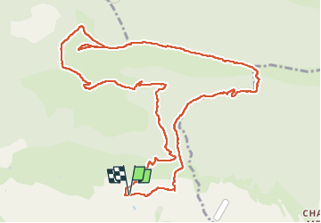

Length
14 km

Max alt
1635 m

Uphill gradient
865 m
Km-Effort
26 km

Min alt
846 m

Downhill gradient
868 m
Boucle
Yes
Creation date :
2024-09-30 07:28:22.792
Updated on :
2024-10-01 12:54:49.697
5h48
Difficulty : Difficult

FREE GPS app for hiking
 SityTrail
IGN / Geographical institutes
SityTrail Plus
The world is yours!
About
Trail Walking of 14 km to be discovered at Provence-Alpes-Côte d'Azur, Hautes-Alpes, L'Épine. This trail is proposed by Clo0413.
Positioning
Country:
France
Region :
Provence-Alpes-Côte d'Azur
Department/Province :
Hautes-Alpes
Municipality :
L'Épine
Location:
Unknown
Start:(Dec)
Start:(UTM)
709009 ; 4922353 (31T) N.
Comments