


ST FLOUR 33 km VTT Paulhac

benoit48
User
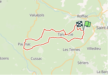

Length
32 km

Max alt
1118 m

Uphill gradient
404 m
Km-Effort
38 km

Min alt
972 m

Downhill gradient
411 m
Boucle
Yes
Creation date :
2018-01-06 00:00:00.0
Updated on :
2018-01-06 00:00:00.0
2h20
Difficulty : Unknown

FREE GPS app for hiking
 SityTrail
IGN / Geographical institutes
SityTrail Plus
The world is yours!
About
Trail Mountain bike of 32 km to be discovered at Auvergne-Rhône-Alpes, Cantal, Saint-Flour. This trail is proposed by benoit48.
Positioning
Country:
France
Region :
Auvergne-Rhône-Alpes
Department/Province :
Cantal
Municipality :
Saint-Flour
Location:
Unknown
Start:(Dec)
Start:(UTM)
503184 ; 4986132 (31T) N.
Comments