


Cretes de Comboire G2

d.rochas
User
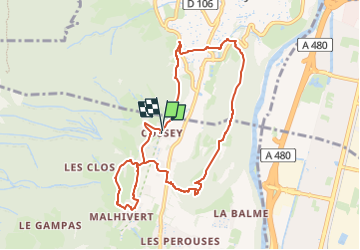

Length
9 km

Max alt
535 m

Uphill gradient
370 m
Km-Effort
13.9 km

Min alt
334 m

Downhill gradient
371 m
Boucle
Yes
Creation date :
2024-09-30 15:17:14.292
Updated on :
2024-09-30 15:18:23.247
3h09
Difficulty : Difficult

FREE GPS app for hiking
 SityTrail
IGN / Geographical institutes
SityTrail Plus
The world is yours!
About
Trail Walking of 9 km to be discovered at Auvergne-Rhône-Alpes, Isère, Claix. This trail is proposed by d.rochas.
Description
Belvedere de Comboire par Cossey et Malhivert
Positioning
Country:
France
Region :
Auvergne-Rhône-Alpes
Department/Province :
Isère
Municipality :
Claix
Location:
Unknown
Start:(Dec)
Start:(UTM)
710035 ; 5002214 (31T) N.
Comments